To get the coordinates from a selected location on the map (Latitude and Longitude) to input fields, we can use Google’s Javascript MAP API. Here i have used a search field to search locations by name. Therefor i had to use Places API too.
How it works
I have used simple Bootstrap4 html page to place map. According to the Google’s documentation guide we can use below Javascript codes to get selected location’s coordinates in to two input fields at the bottom.
<script src="https://maps.googleapis.com/maps/api/js?key=AIzaSyAcr__t5RD7E40Yz6rgEVHQOAI4kcsMrIA&libraries=places&callback=initialize" async defer></script>
<script>
function initialize() {
	var myLatlng = new google.maps.LatLng(7.873053999999999,80.77179699999999);
	var myOptions = {
		zoom: 8,
		center: myLatlng,
		mapTypeId: google.maps.MapTypeId.ROADMAP
	}

	var map = new google.maps.Map(document.getElementById('map-canvas'), myOptions);

	// Create the search box and link it to the UI element.
	var input = document.getElementById('pac-input');
	var searchBox = new google.maps.places.SearchBox(input);
	map.controls[google.maps.ControlPosition.TOP_LEFT].push(input);

	var marker = new google.maps.Marker({
		draggable:true,
		position: myLatlng,
		map: map
	});

	// Bias the SearchBox results towards current map's viewport.
	map.addListener('bounds_changed', function() {
		searchBox.setBounds(map.getBounds());
	});

	google.maps.event.addListener(marker, 'dragend', function (event) {
		var poiLat = this.getPosition().lat();
		var poiLon = this.getPosition().lng();
		$('#latitude').val(poiLat);
		$('#longitude').val(poiLon);
	});

	var markers = [];
	// Listen for the event fired when the user selects a prediction and retrieve
	// more details for that place.
	searchBox.addListener('places_changed', function() {
		var places = searchBox.getPlaces();

		if (places.length == 0) {
			return;
		}

		// Clear out the old markers.
		markers.forEach(function(marker) {
			marker.setMap(null);
		});
		markers = [];

		// For each place, get the icon, name and location.
		var bounds = new google.maps.LatLngBounds();
		places.forEach(function(place) {
			if (!place.geometry) {
				console.log("Returned place contains no geometry");
				return;
			}

			var icon = {
				url: place.icon,
				size: new google.maps.Size(71, 71),
				origin: new google.maps.Point(0, 0),
				anchor: new google.maps.Point(17, 34),
				scaledSize: new google.maps.Size(25, 25)
			};

			// Create a marker for each place.
			marker.setPosition( place.geometry.location );
			map.panTo( place.geometry.location );
			$('#latitude').val(place.geometry.location.lat());
			$('#longitude').val(place.geometry.location.lng());

			if (place.geometry.viewport) {
			// Only geocodes have viewport.
				bounds.union(place.geometry.viewport);
			} else {
				bounds.extend(place.geometry.location);
			}
		});

		map.fitBounds(bounds);
	});
}

</script>
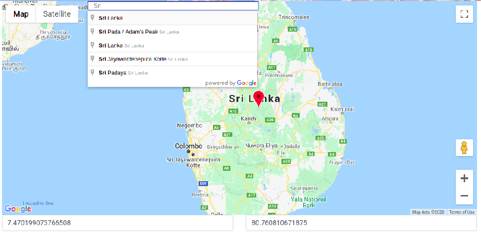
Here is the final output.
You can download the source code from my Github: https://github.com/lahirutm/Get-coordinates-using-Google-s-Javascript-API